Arboreal Tree Gets 3D Scanning, Point Clouds, and a New Premium Tier for Urban Forestry
Johan Ekenstedt
18 Mar 2026
Measuring a tree used to mean standing at a distance with a clinometer and hoping the math worked out. Then Arboreal Tree made it possible to measure tree height, crown dimensions, diameter, and inclination from a phone. Today, we are taking the next step — turning your phone into a full 3D tree measurement system.
This update is the biggest since the app launched. It brings new capabilities to every user at no extra cost, plus a new Premium tier built specifically for urban forestry professionals.
What every user gets
Two major additions are now available to all Arboreal Tree users on iOS.
3D tree scanning is the headline feature. Using your phone's LiDAR sensor, you can now scan a tree and generate a full point cloud and 3D model on-site. It is a capability that, until recently, required dedicated hardware costing thousands of euros. Now it runs on the device already in your pocket.
Cloud sync keeps your measurement data and up to 200 images backed up and accessible on the web. Now you will keep your measurements even if you lose your phone.
Arboreal Tree Premium: a field measurement system for urban forestry
For arborists, city foresters, and consultants who need more than height measurements, the new Premium tier turns Arboreal Tree into a complete field tool.
Point cloud export. Every 3D scan can be exported for use in CloudCompare, CAD, GIS, or 3D modelling software. Your field data flows directly into whatever analysis pipeline you already use — no format conversion headaches.
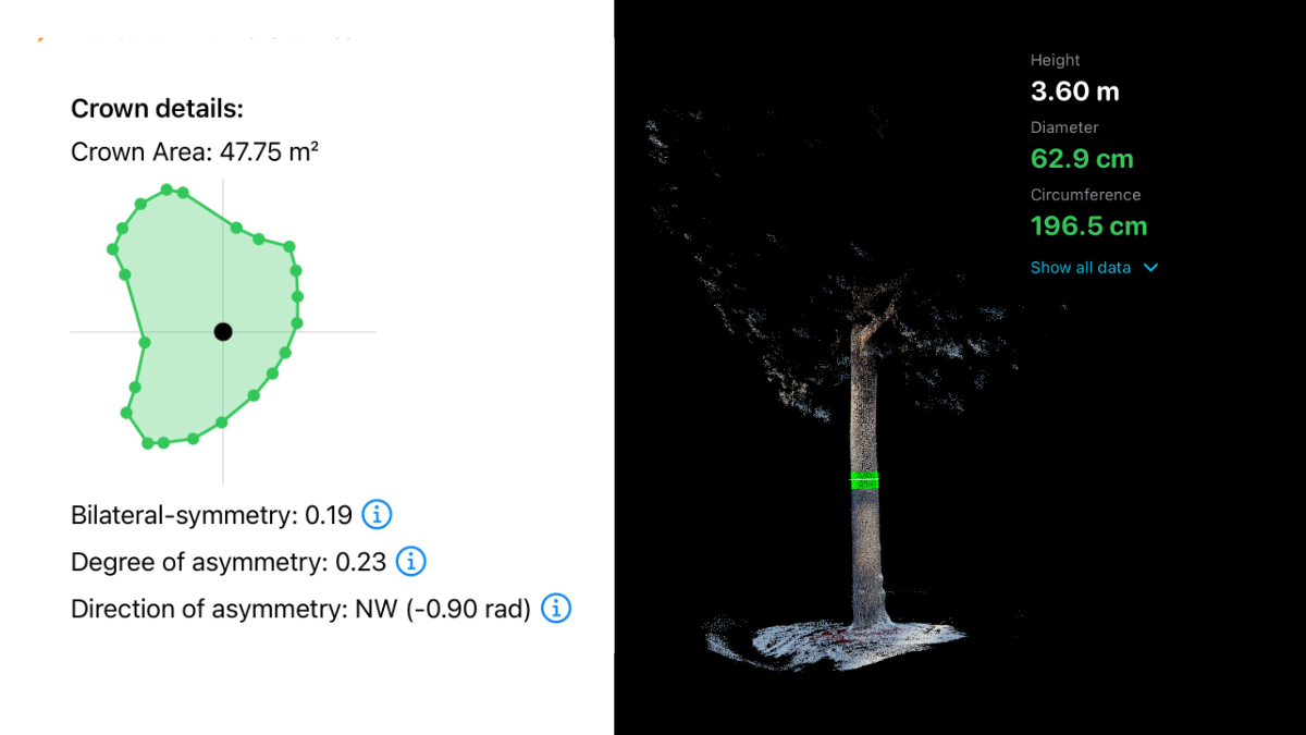
Circumference in the point cloud. Instead of wrapping a tape around the trunk, measure circumference directly in the 3D model. It is accurate, repeatable, and fully documented alongside your other measurements.
Crown shape analysis. Premium adds quantitative crown metrics, including asymmetry measurements. For risk assessments and vitality evaluations, having objective crown data — rather than a subjective field note — changes the quality of your reporting.
Multi-tree sessions. Measure multiple trees in a single session, all sharing the same coordinate system. Walk a street, scan every tree, and export one unified, spatially consistent dataset. No stitching. No post-processing alignment.
Emlid GNSS support. Pair Arboreal Tree with an Emlid Reach RX or RX2 receiver for centimetre-level positioning accuracy. For inventories and planning projects where spatial precision matters, this turns a phone-based workflow into something that rivals dedicated survey equipment.
Cloud image storage. Save and sync up to 2,000 high-resolution images to the cloud. Document conditions, defects, and surroundings — all linked to your measurements.
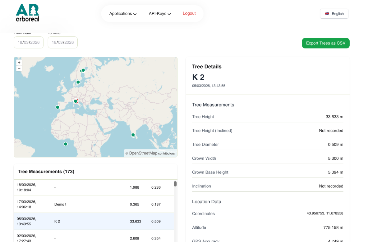
All measurements that are synced are available on the web at arboreal.se/en/login.
Who is Premium built for?
Whether you are assessing a single tree or managing a city-wide inventory, Premium gives you the tools to work faster and document better.
Municipal arborists and city foresters managing urban tree inventories benefit from multi-tree sessions and GNSS support — capturing entire streets in a single workflow. Consulting arborists conducting risk assessments gain crown asymmetry metrics and exportable point clouds that strengthen their documentation. Environmental consultants and landscape architects get accurate 3D tree data they can import directly into their design and planning tools. Research teams collecting standardised measurement data get a repeatable, instrument-grade method that fits in a pocket.
What a modern urban tree inventory looks like
Arrive at the site with your phone and, optionally, an Emlid GNSS receiver. Open a multi-tree session in Arboreal Tree Premium. Walk the area and measure each tree as you go — height, circumference, and crown shape all recorded in one session. When you are done, export the georeferenced dataset and import it directly into your GIS. No clipboard, no manual data entry, no office hours spent aligning separate files.
Getting started
The update — 3D scanning and cloud sync — is available now on iOS. Download or update Arboreal Tree from the App Store and the new features are ready to use.
Premium is available as an upgrade within the app. Whether you manage ten street trees or ten thousand, it is built to match the scale of your work.
Written by

Johan Ekenstedt
CEO and iOS developer at Arboreal. Making it easier to measure, understand and manage trees and forests.
LinkedIn